There’s a trail that runs along the forested ridge above the school. With summer phasing into fall, and the smell of winter in the air, I decided to offer cross-country running as my P.E. option this quarter.
Just getting to the ridge-top is a strenuous jog up a steep slope (note to self: I need to get the geometry students to calculate the slope), especially with the thick, slippery layer of this fall’s accumulated leaves to test the unwary, and I was a little surprised that about half a dozen students actually took me up on it.
Climbing the steep, slippery, leaf-covered slope is not trivial.
Indeed a few more students have accreted onto our group since we started, casualties of the other P.E. options for the most part. But I’d like to think that the beauty of the wooded landscape — brilliant elm and sugar maple leaves littering the ground; crisp, cool air against flushed skin; the fresh, decisive smells in the ridge-top air; the crack an crackle of leaves underfoot — may have also attracted some attention.
I’m looking forward to observing how the slope and forest change with the coming winter.
Brandon Kelm explains a little of how it works, mostly using terms like “scale-free correlation” and “criticality”, which pretty much sums up that we don’t know a lot about the phenomena.
NetLogo has a nice little Java model showing an attempt at simulating flocking. They give a good description of how there model works.
There’s a place on the road to school where you crest a little rise and the St. Albans golf course opens up before you. “Zen-like,” I’ve heard it described. On one lovely fall morning last week the view was absolutely ridiculous. I had to stop.
Resisting the coming winter, warmer air from down south just pushed over the hills overnight, trapping the cooler air in the valley, creating a thermal inversion that trapped a layer of fog just below the tops of the hills. Small tendrils of mist were rising off lake in the bottom of the valley, feeding the fog layer as the cooler valley air condensed the water vapor evaporating off the still warm lake.
Combine the fog, mists, early morning sunlight just beginning to reach into the valley, and the brilliant fall colors contrasting against the still-green lawns, and the result was absolutely amazing.
Not being able to leave well enough alone, I've also put together this "3d" gif. It does show the fog on the lake nicely though.
The first thing you notice is a small, rickety bridge whose main job is to keep your feet dry as you cross a very small stream. The stream is on its delta, so the ground is very soggy, and the channel is just about start its many bifurcations into distributaries that fan out and create the characteristic deltaic shape.
Delta and estuary of the small stream near the villas.
There’s a bright orange flocculate on the quieter parts of the stream bed. It’s the color of fresh rust, which leads me to suspect it’s some sort of iron precipitate.
It is quite easy to stick your finger into the red precipitate at the bottom of the stream.
Iron minerals in the sediments and bedrock of the watershed are dissolved by groundwater, but when that water discharges into the stream it becomes oxygenated as air mixes in. The dissolved iron reacts with the oxygen to create the fine orange precipitate. Sometimes, the chemical reaction is abiotic, other times it’s aided by bacteria (Kadlec and Wallace, 2009).
The bark has been chewed off the top half of this stick. The tooth marks are characteristic of beavers.
Past the small delta, the trail follows the lake as it curves around into another, much bigger estuary (see map above). We found much evidence of flora and fauna, including signs of beavers.
We even took the time to toss some sticks into the water to watch the waves. With a single stick, you can see the wave dissipate as it expands, much like I tried to model for the height of a tsunami. We also threw in multiple sticks to create interference patterns.
Observing interference patterns in waves.
The Oak Ridge Trail, which we followed, diverges from the somewhat longer Pin Oak Trail at the large estuary (which is marked on the map). The Pin Oak Trail takes you through some beautiful stands of conifers, offering the chance to talk about different ecological communities, but we did not have the time to see both trails.
Instead, we followed the Oak Ridge Trail up the ridge (through one small stand of pines) until it met the road. The road is on the other side of the watershed divide. I emphasized the concept by having my students stand in a line across the divide and point in the direction of that a drop of water, rolling across the ground, would flow.
At the watershed divide.
Then I told them that we’d get back by following our fictitious water droplet off the ridge into the valley. And we did, traipsing through the leaf-carpeted woods.
Students imitating water droplets find a dry gully.
Of course there were no water droplets flowing across the surface. Unless its actively raining, water tends to sink down into the soil and flow through the ground until it gets to the bottom of the valley, where it emerges as springs. Even before you see the first spring, though, you can see the gullies carved by overland flow during storms.
Spring.
Following the small stream was quite enjoyable. It was small enough to jump across, and there were some places where the stream had bored short sections of tunnels beneath its bed.
The stream pipes beneath its bed. Jumping up and down over the pipe caused sediment to be expelled at the mouth of the tunnel.
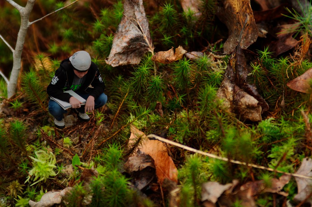
I took the time to observe the beautiful moss that maintained the banks of the stream. Students took the time to observe the environment.
Taking a break at the confluence of two streams.
Downstream the valley got wider and wider, and the stream cut deeper and deeper into the valley floor, but even the small stream sought to meander back and forth, creating beautiful little point bars and cut-banks.
A small, meandering channel. Note the sandy point bars on the inside of the bend, and the overhanging cut-banks on the outside of the curve.
As the stream approached its estuary it would stagnate in places. There, buried leaves and organic matter would decay under the sediment and water in anoxic conditions, rendering their oils and producing natural gas. We’re going to be talking about global warming and the carbon cycle next week so I was quite enthused when students pointed out the sheen of oils glistening on isolated pools of stagnant water.
The breakdown of buried organic matter produces gas and oils that are less dense than water.
Finally, we returned to the estuary. It’s much larger than the first one we saw, and it’s flat, swampy with lots of distributaries, and chock full of the sediment and debris of the watershed above it.
View of the lake from the estuary. The red iron floc in the stream made for a beautiful contrast with the black of the decaying leaves. There is so much red precipitate that it is visible on the satellite image.
This less than three kilometer hike took the best part of two hours. But that’s pretty fast if you value your dawdling.
The Trans Alaska pipeline. The bend is due to the fact that it's sitting on a faultline. (Image via the USGS)
Back in 1991, Jay Anderson wrote and interesting article (free pdf) on how exactly to go about measuring “naturalness”.
After all, anywhere you go in this world, you’ll find it has been impacted by humans to some degree: agriculture in Brazil is affecting rainfall patterns in the remotest parts of the Amazon basin; and soot and anthropogenic chemicals gently, and subtly, contaminate the remotest Antarctic Ice Caps.
Anderson came up with three things to look at, but I think the two key are:
how much things would change if you removed people,
how many native species there are compared to how many their were in the past.
I think it’s important to try to at least better define what we mean by the word “natural” as we think about conserving the environment.
The World without Us by Alan Weisman
Anderson’s first point, about how much things would change if you removed the people, also brings to mind Alan Weisman’s book, The World without Us, which imagines what the world would look like if humans disappeared: what would happen to the cities and artifacts we leave behind?
Footprints in the sand of a small bay on the northeastern coast of Trinidad.
It’s a great starting point for looking at the tree of life because each page has links to a wealth of online resources. One of the links on the Mammalia page, for example, is to Faunmap, an online database that produces maps of where different modern and extinct mammalian species can be found in the United States.
All the pages on the Tree of Life website are linked by the branches of the tree of life. The Class Mammalia links up to its parent Therapsida and down to the its Orders such as Monotremata (one of my favorites) and Eutheria, the placenta mammals.
The site is authored by professional scientists and science educators so has that credibility. Most of the images also allow free, non-commercial use. Thanks to Anna C. for the link.
Since we’re focusing on the life sciences this year I want to complete the nature trail. Part of this project is to catalog the biodiversity on the trail. I’d like to have students specialize on the different types of organisms we find. Undoubtedly, the Class Insecta will be well represented. The site, Entomology for Beginners is a great basic resource. It starts with very simple cartoons of insect parts but also has a great key to insect orders which walks you through the comparisons you need to make to identify the Orders in which a particular insect belongs.


