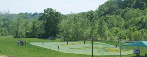
One of the games Dr. A. plays with the middle school geography class is to have them use the soccer field as a large map. They chose a place and someone runs to its location on the field. What I like is that he insists that the map be all in their heads. They might have one or two control points, but they have to visualize the map mentally.
I saw them out on the soccer field today, and I thought I’d make their imaginary map a little more literal in Gimp.
UPDATE: Dr. A[ustin] clarifies the rules of the competitive game they were playing in the comments below, in case anyone wants to try it.
Update 2: Move your mouse over the image below to see the picture with or without the map (larger version here).
Clarification from Dr. A, in case anybody wants to try it. The activity was competitive. Two teams of 8. The team “challenging” names a location; the team “marking” has 5 seconds to confer and then 10 seconds to put a body on the corresponding spot on the field. Once the marker is on the way to the spot, her team cannot shout directions or point. So on through the whole marking team, and then switch challenging and marking, through 5 rounds. After each half round, the teacher goes to zero x zero and awards points (this is what’s happening in the picture). For the record, the 7th grade beat the 8th grade yesterday, 15 1/2 to 15. It was intense, cooperative, physical, and fun.