On this year’s trip to the Current River with the Middle School we were able to see outcrops of the three major types of rocks: igneous, metamorphic, and sedimentary.
Igneous Rocks
Beautiful, pink granite at Elephant Rocks State Park.
We stopped by Elephant Rocks State Park on the way down to the river to check out the gorgeous pink granite that makes up the large boulders. The coarse grains of quartz (translucent) interbedded with the pink orthoclase crystals make for an excellent example of a slow-cooling igneous rock.
Metamorphic Rocks
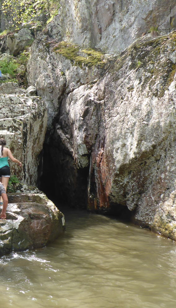
The Prairie Creek waterfall pool.
On the second day out on the canoes we clambered up the rocks in the Prairie Creek valley to see jump into the small waterfall pool. The rocks turned out to look a lot like the granite of Elephant Rocks if the large crystals had been heated up and deformed plastically. This initial stage of the transformation allowed me to talk about metamorphic rocks althought we’ll see some much more typical samples when we get back to the classroom.
Prairie Creek rocks.
Sedimentary Rocks
Limestone bluffs along the Current River.
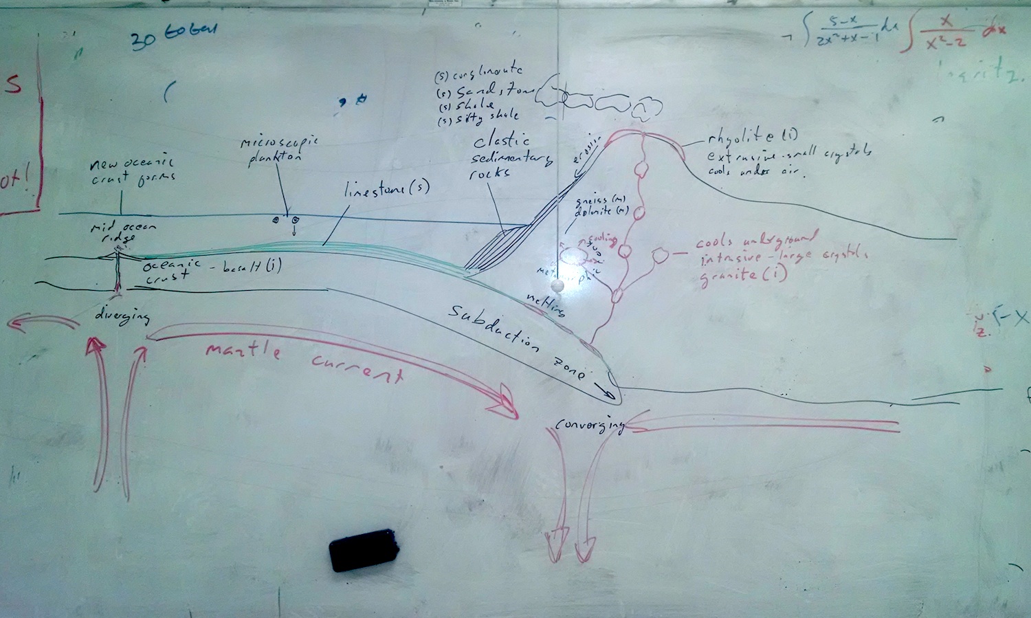
We visited a limestone cave on the third day, although we’ve been canoeing through a lot of limestone for on the previous two days. This allowed us to talk about sedimentary rocks: their formation in the ocean and then uplift via tectonic collisions.
The Rock Cycle
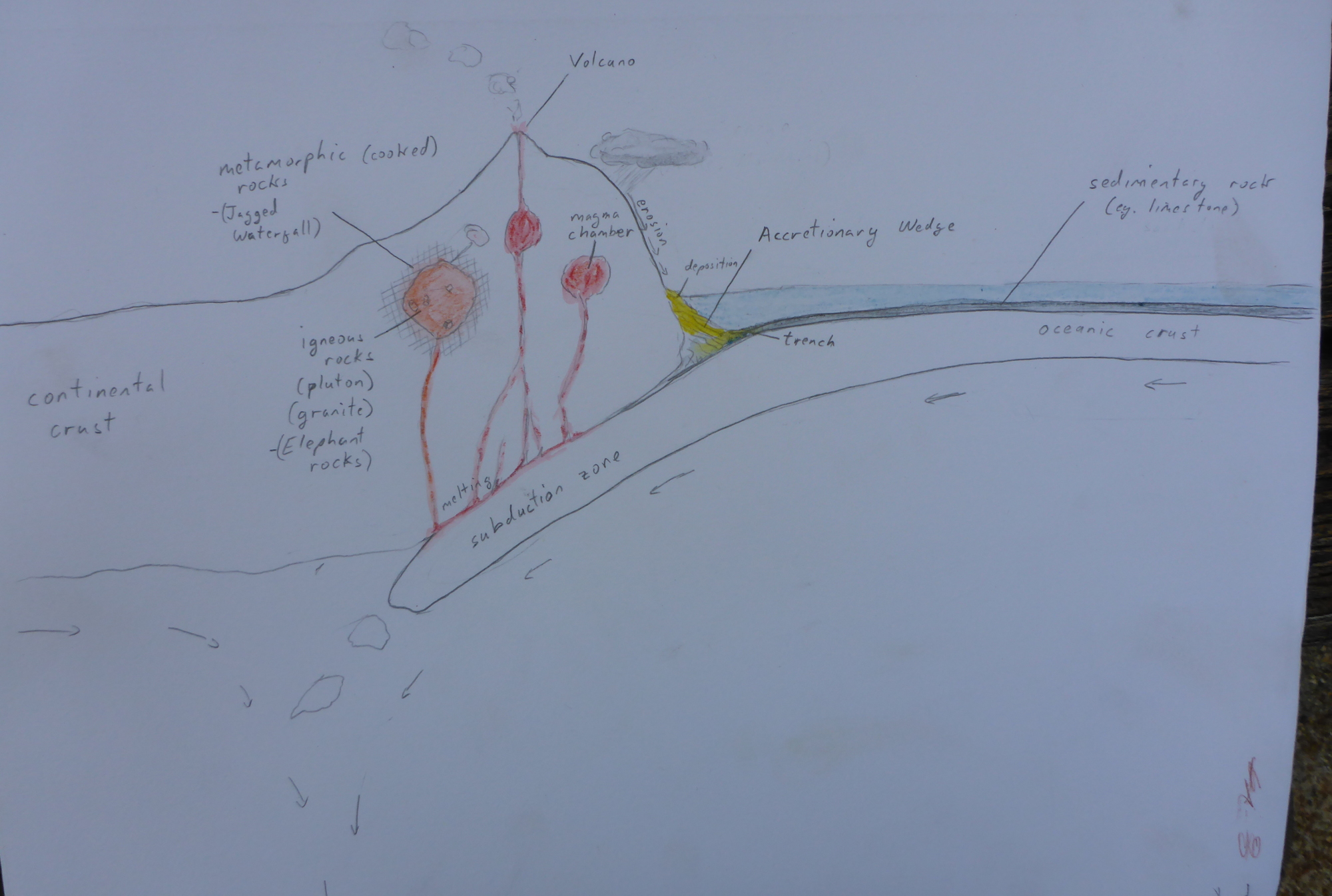
Diagram of a convergent tectonic margin used to illustrate the rock cycle.
Back at camp, we summarized what we saw with a discussion of the rock cycle, using a convergent plate margin as an example. Note: sleeping mats turned out to be excellent models for converging tectonic plates.
Note to self: It might make sense to add extra time at the beginning and end of the trip to do some more geology stops. Johnson Shut-Inns State Park is between Elephant Rocks and Eminence, and we saw a lot of interesting sedimentary outcrops on the way back to school as we headed up to Rolla.
The picture of a convergent tectonic boundary pulls together our immersion trip to Eminence, and the geology we’ve been studying this quarter. We saw granite boulders at Elephant Rocks; climbed on a rhyolite outcrop near the Current River; spelunked through limestone/dolomitic caverns; and looked at sandstone and shale outcrops on the road to and from school.
The subducting plate melts producing volatile magma.
With a larger class, and quite a bit of space in the gym, I had more flexibility working on the toilet paper timeline compared to the last time.
Labeling the timeline in the gym.
I built in a friendly race to see which group could find a set of events first, and allowed me to highlight nine different, important, series of events along the timeline.
I broke the class up into 4 groups of 4, and each group created their own timeline based on a handout.
Groups of students lay out their toilet paper timelines. Post-it notes were used to label the events.
Then, I gave each group a slip of paper with four events on it (one event per student), and they had to race to see which group would be first to get one person to each event on the list. Once each group got themselves sorted out, I took a few minutes to talk about why the events were important and how they were related.
Table 1: The series of events.
1) We’ll be talking about plate tectonics soon, so it’s good for them to start thinking about the timing of the formation and breakup of the supercontinents.
Event 1
Event 2
Event 3
Event 4
Formation of Rodinia (supercontinent)
Breakup of Rodina
Formation of Pangea
Breakup of Pangea
2) This sequence emphasizes the fact that most free oxygen in the atmosphere comes from ocean plants (plankton especially), and that a lot of free atmospheric oxygen was needed to to form the ozone layer which protected the Earth’s surface from uv radiation, which made the land much more amenable to life. Also, trees came way after first plants and oxygen in the atmosphere.
Event 1
Event 2
Event 3
Event 4
First life (stromatolites)
Oxygen buildup in atmosphere
First land plants
First Trees
3) Pointing out that flowering plants came after trees.
Event 1
Event 2
Event 3
Event 4
First life
First land plants
First trees
First flowering plants
4) The Cambrian explosion, where multicellular life really took off, happened pretty late in timeline. Longer after the first life and first single-celled animals.
6) More tectonic events we’ll be talking about later.
Event 1
Event 2
Event 3
Event 4
Opening of the Atlantic Ocean
Linking of North and South America
India collides with Asia
Opening of the Red Sea
7) Pointing out that life on land probably needed the magnetic field to protect from the solar wind (in addition to the ozone layer).
Event 1
Event 2
Event 3
Event 4
Formation of the Earth
First life
Formation of the Magnetic Field
First land plants
8) Fish came before insect. This one seemed to stick in students’ minds.
Event 1
Event 2
Event 3
Event 4
First Fish
First Insects
First Dinosaurs
First Mammals
9) Mammals came before the dinosaurs went extinct. This allowed a discussion of theories of why the dinosaurs went extinct (disease, asteroid, mammals eating the eggs, volcanic eruption in Deccan) and how paleontologists might test the theories.
Event 1
Event 2
Event 3
Event 4
First Dinosaurs
First Mammals
Dinosaur Extinction
First Primates
The whole exercise took a few hours but I think it worked out very well. The following day I gave the quiz, posted in the excel file, where they had to figure out which of two events came first, and the students did a decent job at that as well.
Classification of american bison and water buffalos.
American bison (Bison bison) are native to North America, while water buffalo (Bubalus bubalis) are from Africa. They are different species, and each are classified in a different genus, however, they belong to the same Family, Bovidae. Since it’s highly unlikely that there was any genetic intermingling after Africa separated from North America, if we can figure out how long ago the two continents were together, we can estimate how long ago their common ancestor lived, and how fast evolution occurs (at least in large mammals).
Continental Rifting
North America is moving away from Africa at an average spreading rate of about 2.5 cm/year, and the continents are about 4550 km apart.
To figure out how long it has been since the continents were together, we need to convert the distance into the same units as the spreading rate and then divide by the rate.
Converting the distance to cm:
Finding the time:
So we get 182 million years.
Evolutionary Rates
Now to get really back-of-the-envelope. If it takes 182 million years to be separated by two levels of classification (the genus and species levels), then it takes approximately 91 million years for each level of classification.
If we extend this backwards up the phylogenetic tree (species –> Genus –> Family –> Order –> Class –> Phylum –> Kingdom ), which is probably illegal, we get a grand total of six levels of classification back to the divergence of the plant and animal kingdoms. That’s 546 million years, which is remarkably close to the time of the first fossil records of complex multi-cellular life, somewhere near the beginning of the Cambrian about 540 million years ago.
The major caveat, however, is that the first phylogenetic step, from Domain to Kingdom took a lot longer than our 91 million year average, since the first life appeared on Earth about 4 billion years ago.
Conclusion
There are lots of issues with this analysis, but the result is curiously coincidental. I’d really appreciate any thoughts on the validity of this particular exercise.
Note:
The spreading happens at the Mid-Atlantic Ridge, which bifurcates the Atlantic. However, if you look at a map of the bathymetry of the North Atlantic, you can see long striations — lines — that show the direction of the tectonic plate motion. The distance the continents moved are best measured along this line.
Rain falls.
Some runs off,
Some seeps into the ground.
Water drips from the tips of limestone straws on the roof of Twins Cave.
It trickles through soil.
Leaching acids, organic,
Out of the leaf litter,
But even without these,
It’s already, every so slightly, corrosive, From just the carbon dioxide in the air.
Gravity driven,
The seeping water seeks the bedrock,
Where it might find,
In the Ozark Mountains,
Limestone.
Planktonic shell (from Coon Creek which is 30 million years old, compared to the limestone rocks in the Ozarks which are 300 million years old.)
Limestone:
Microscopic shells, of plankton,
Raining down, over millenia,
Compacting into rocks,
In a closing ocean,
As North America and Africa collide,
From the Devonian to the Carboniferous.
Orogenic uplift,
Ocean-floor rocks,
Become mountains,
Appalachians, Ouachitas,
The Ozark Plateau.
The collision of North America and Africa uplifted the limestone rocks from the closing ocean (the Rheic Ocean) to create the Ouachita Mountains and Ozark Plateau. (Figure adapted from iimage by Dr. Ron Blakey - http://jan.ucc.nau.edu/~rcb7).
Limestone dissolves,
In acid water.
Shaping holes; caves in bedrock,
Where we go,
Exploring.
Clays and Silts (mud) deposited when the river floods.
Bedrock. Mostly limestone:
Can be found outcropping on the hills.
Mississippian Limestones (USGS ref.) (330-360 million years old.): found on some of the hilltops.
Ordovician Dolomites and Limestones (USGS ref.) (435-500 million years old)
The geology of St. Albans consists of young floodplain sediments (yellow), and old limestone bedrock (blue). Image adapted from the USGS.
Geologic History
The continents form
To reconstruct the geologic history, we can start a bit deeper, with the fact that we’re sitting in the middle of a continent, which means that if you drill deep enough you’ll get to some of the original, granitic rocks that formed just after the crust of the Earth cooled — about four and a half billion years ago.
The froth that floats on top of the boiling jam is a bit like the continental crust.
The continental crust is a bit like the froth that forms on moving water (or the top of boiling jam), and just like froth it tends not to want to sink. So there’s some pretty old continental crust beneath the continents.
However, also just like froth on water, the continental crust is pushed around on the surface of the Earth. This is called continental drift (which is part of the theory of plate tectonics). Sometimes, the continental crust can split apart, making space for seas and oceans between the drifting continents, and causing parts of the continent to subside beneath the oceans.
At other times, such as when two continents collide, they can push each other up to mountains out of areas that were once seas.
And that’s how we ended up with limestone rocks in the middle of Missouri.
Forming Limestone Rocks (Ordovician)
Five hundred million years ago (500,000,000 years ago) the continents were in different places, and Missouri was under a shallow part of the Iapetus Ocean.
The location of Missouri 458 million years ago. Image from: "Plate tectonic maps and Continental drift animations by C. R. Scotese, PALEOMAP Project (www.scotese.com)"
Many of the micro-organisms that lived in that ocean made shells out of calcium carbonate.
100 million year old, calcium carbonate shell (from Coon Creek).
When you accumulate billions of these shells over the course of millions of years, and then bury them, compress them, and even heat them up a bit, you’ll end up with a rock made of calcium carbonate. We call that type of rock: limestone.
Limestone outcrop on St. Albans Road (Ordovician).
Emerging from the Oceans: The Formation of Pangea.
The Mississippian limestone rocks formed in the same way, but about 360 million years ago. Why is there a gap between the Ordovician rocks (450 million years ago) and the Mississippian ones? Good question. You should look it up (I haven’t). There may have been rocks formed between the two times but they may have been eroded away.
I can make a good guess as to why there are no limestone rocks younger than about 300 million years old, however. At that time the continents, which had been slowly sidling toward each other, finally collided to form a super-continent called Pangea.
What would become North America (called Laurentia), ran into the combined South America/Africa continent (called Gondwana) pushing up the region, and creating the Ozarks and Appalachian Mountains.
Laurentia collides with Gondwana. Image from "Plate tectonic maps and Continental drift animations by C. R. Scotese, PALEOMAP Project (www.scotese.com)"
And that’s the story the geology can tell.
References
The USGS has good, detailed, interactive maps of the geology of the states in the US.
A nice geologic map of St. Louis County can be found here.
A geologic time scale from the USGS. The geologic time scale. From the USGS via Wikipedia.
Moving charges create magnetic fields. Currents moving through a wire are moving electric charges (electrons). Therefore, current-carrying wires generate a magnetic field around them.
Bending wires into a loop will create will create a magnetic field through the loop.
The more loops you have the stronger the magnetic field.
The magnets created by pushing a current through loops of wire is called an electromagnet.
If you use superconducting wire, you can create an extremely powerful superconducting magnet that can be used in magnetic levitation (maglev) trains.
Magnetic field through a coil of wire (with a current running through it). The more loops of the wire, the stronger the electric field.
Magnets Deflect the Movement of Charged Particles (36.6)
Moving charged particles create magnetic fields. So if a moving charged particle encounters a magnetic field the two magnetic fields will interact and the motion of the particle will be deflected.
A charged particle is deflected from it's forward motion when a magnetic field is turned on.
Note that the deflection only occurs when the particle is not traveling parallel to the magnetic field lines.
The big, old styled TV’s use this to shoot electrons at the screen to make the picture.
The Earth’s magnetic field deflects the charged particles ejected by the Sun, protecting the planet.
The Earth's magnetic field protects us from the solar wind. Image from NASA.
Interaction Between Magnets and Currents in Wires
Just like charged particles are deflected when they run into a magnetic field, charges running through a wire will create a magnetic field that will interact with external magnets to cause the wire to move.
The force on the wire is perpendicular both to the direction of the current and the lines of the magnetic field.
If you reverse the current in the wire (send it the other way) the force will be in the opposite direction.
The force resulting from a current is at right angles to the magnetic field and the current; the "right hand rule" is an easy way to remember this. Image adapted from User:Acdx on Wikimedia Commons.
You can use this principle to create a galvanometer, which is a device that detects electric currents, or to build motors.
A simple electric motor.
Earth’s Magnetic Field
Convection currents in the Earth’s molten, metalic outer core create the Earth’s magnetic field.
Because the pattern of convection changes over time, the Earth’s magnetic field:
Is not located at the north pole (axis of rotation).
Wanders: it moves a little each year.
Flips so its poles reverse every 800,000 years or so.
The location of the magnetic north pole changes with time. Image via the National Forest Service.
As lava cools, the magnetic minerals in it orient themselves with the Earth’s magnetic field. One way of telling how old basalt rocks on the seafloor are is by looking at the direction of their magnetic field. Since the Africa and the Americas are moving apart, slowly over millions of years, there is a suture in the Earth’s crust in the middle of the Atlantic ocean where new seafloor is made from erupting, under-sea volcanos. As a result, there are magnetic stripes all along the Atlantic Ocean (and all the other oceans too) that have recorded each time the Earth’s magnetic polarity has reversed.
Magnetic striping in oceanic crust. Image from the USGS.
The inner core of the Earth is made of solid metal, mostly iron. The outer core is also made of metal, but it’s liquid. Since it formed from the solar nebula, our planet has been cooling down, and the outer core has been freezing onto the inner core. Somewhat counter-intuitively, the freezing process is a phase change that releases energy – after all, if you think about it, it takes energy to melt ice.
The energy released from the freezing core is transported upward through the Earth’s mantle by convection currents, much like the way water (or jam) circulates in a boiling pot. These circulating currents are powerful enough to move the tectonic plates that make up the crust of the earth, making them responsible for the shape and locations of the mountain ranges and ocean basins on the Earth’s surface, as well as the earthquakes and volcanics that occur at plate boundaries.
Conceptual drawing of assumed convection cells in the mantle. (via The Dynamic Earth from the USGS).
Eventually, the entire inside of the earth will solidify, the latent heat of fusion will stop being released, and tectonics at the surface will slow to a stop.
The topic came up when we were talking about the what heats the Earth. Although most of the energy at the surface comes from solar radiation, students often think first of the heat from volcanoes.
Note: An interesting study recently published showed that although the core outer core is mostly melting, in some places it’s freezing at the same time. Unsurprising given the convective circulation in the mantle.
Model of convection in the Earth's mantle. Notice that some areas on the mantle are hotter, creating hot plumes, and some are cooler (image from Wikipedia).
Note 2: Convection in the liquid outer core is what’s responsible for the Earth’s magnetic field, and explains why the magnetic polarity (north-south) switches occasionally. We’ll revisit this when we talk about electricity and dynamos.


