Sharing and privacy online

How your personal information, provided to Facebook, has become accessible to the rest of the web.

People, kids and adults, are still adjusting to the privacy implications of sharing information online. Not only are we figuring out what to post for the public on social networking websites like Facebook or our blogs, but we’re also deciding what information we want to give to the websites themselves as companies try to tailor a unique online experience for each of us (as with targeted advertising). Laura Holson has an interesting article under the headline, “Tell-All Generation Learns to Keep Things Offline” about how some young adults are scaling back their online sharing as they realize how potential colleges and employers can use that information, especially negative information.

… people ages 18 to 29 were more apt to monitor privacy settings than older adults are, and they more often delete comments or remove their names from photos so they cannot be identified. Younger teenagers were not included in these studies, and they may not have the same privacy concerns. But anecdotal evidence suggests that many of them have not had enough experience to understand the downside to oversharing. – Holson, 2010.

Sharing is a way to increase transparency, which is often a good thing. Learning more about each other may help create a more peaceful world. But privacy can be equally important. We all make mistakes, say things we should not, do things we shouldn’t, especially when we’re young. When we recognize those mistakes and learn from them, there should come a time when they are not held against us.

The web needs a statue of limitations, say five years, so anything about us on the web that’s older than five years should not count. Or perhaps, just as minors can’t be held fully responsible for their actions under the law, non-adults should be held to a different standard on the web.

It is, however, notoriously difficult to erase anything from the web, and I tend to be quite conservative when it comes to sharing things online. Yet the greatest power of the internet, I believe, is that it is based a philosophy similar to the constructivist approach to education. In education the student is constructing their own learning, whereas on the internet, society is constructing and organizing information in ways that look a lot like learning.

So our class Wiki is private, as are our students’ blogs. They provide safer spaces for students to make mistakes, but gives them that essential experience of constructing the internet, not just taking away.
Child labor in the U.S.

Child labor comes up when we talk about the industrial revolution. When we discuss its modern incarnations, we usually think about sweatshops in the developing world. Human Rights Watch has a poignant video about child labor in the United States today. Their interviews with migrant farmer children, who are the same age as our middle-schoolers, are heartbreaking.

Living in peace

This blog is my experiment with how my own small and everyday choices for peace impact my life and others. – Peggy Pate-Smith (2010) in “Peace is a choice”

Everyday choices often have a far-reaching impact because we live in a world that’s so interconnected. I tend to think in terms of the environmental impact of my actions: Do I buy this pair of shoes that may have been made by child labor in China? If I get a new, better cell phone will the old one be recycled properly or will it shipped off to some developing country where its corrosion will contaminate the water supply?

Peggy Pate-Smith from Park View Montessori‘s Middle School in Jackson, TN has been thinking about peace. Her blog, appropriately titled Peace is a Choice, logs her thoughts on small and big matters regarding peace. I’ve found it a great place to find out about peace projects, many with a Montessori link, in which students might be interested in participating.

This year I decided to do an experiment with peace. My hypothesis is that if each day I make at least one conscious decision to choose peace in my life AND blog about it that I will find my life more peaceful. I want to move beyond imagining peace and make a deliberate effort to choose peace. Peggy Pate-Smith (2010) in “Peace is a Choice”.

Ms. Pate-Smith’s master’s thesis, “Implications of Peace in the Montessori Environment” won American Montessori Society’s 2007 Outstanding Master’s Thesis Award.

Vietnam in pictures

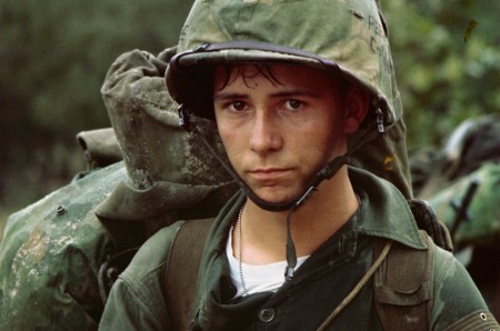
American Marine in Da Nang, Vietnam, August 3, 1965. (Image from the U.S. Marine Corps.)

A slew of ideas and conflicts swirl around the Vietnam War: democracy, communism, dictatorship, freedom, colonialism, domino theory, chemical warfare, technology …. We’re supposed to look at wars through the lens of the “Characteristics of War”, but what do offense and defense mean in a war like Vietnam? A close examination of any of these words in the face of Vietnam leaves more questions than answers. The Boston Globe has a heartbreaking collection of images from the Vietnam War that give a remarkably multifaceted view of the conflict and its consequences. The photos are iconic and some are graphic.

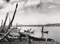
A guerrilla in the Mekong Delta paddles through a mangrove forest defoliated by Agent Orange (1970). Photograph by Le Minh Truong © National Geographic Society (from the International Center for Photography).

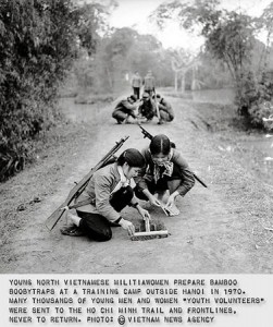
The photographs in the Boston Globe were mostly taken by western photographers (some were from the U.S. military), whose journalistic culture inspired them to try to capture all aspects of the war, to tell the whole story, independent of their own allegiance. There were fewer North Vietnamese photographers and their job was to capture images that would promote their side of the war. Even so, some of their photographs are also amazing and offer another perspective.

Photograph taken by a North Vietnamese war photographer (from SmugMug).

National Geographic collected some of these photos in Another Vietnam: Pictures of the War from the Other Side. More photos are available from SnugMug.com, and National Geographic has a documentary on North Vietnamese photographers called, Vietnam – The Unseen War (a 5 minute preview is available on VEOH).

These images help tell the story of how powerful the media can be, particularly in a democracy. What’s also interesting is the youth of many of the combatants on both sides.

[googleMap name=”Vietnam” width=”490″ height=”350″ mapzoom=”4″ mousewheel=”false” directions_to=”false”]Vietnam[/googleMap]

Nashville flooding and mid-latitude cyclones

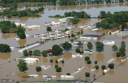
Nashville, TN, May 4, 2010. (photo by David Fine/FEMA)
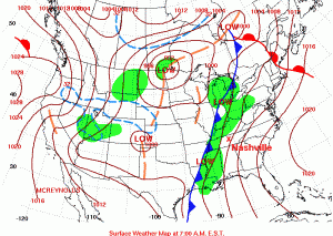
Daily weather map for May 2nd, 2010. Note the cold front heading toward Nashville. Map from the Hydrometeorological Prediction Center.

Over 30 cm of rainfall in just two days resulted in extensive flooding in Nashville, TN, last week. The precipitation was produced by one of those typical mid-latitude cyclones that sweep across the United States, from west to east, every spring and fall. The Boston Globe has some amazing picture of the flooding.

The news media tends to have the most dramatic photographs of disasters, but the Federal Emergency Management Agency (FEMA) also tends to have good images from their aerial surveys (like the image at the top of this post). And images produced by the government are in the public domain so you don’t have to worry about using them.

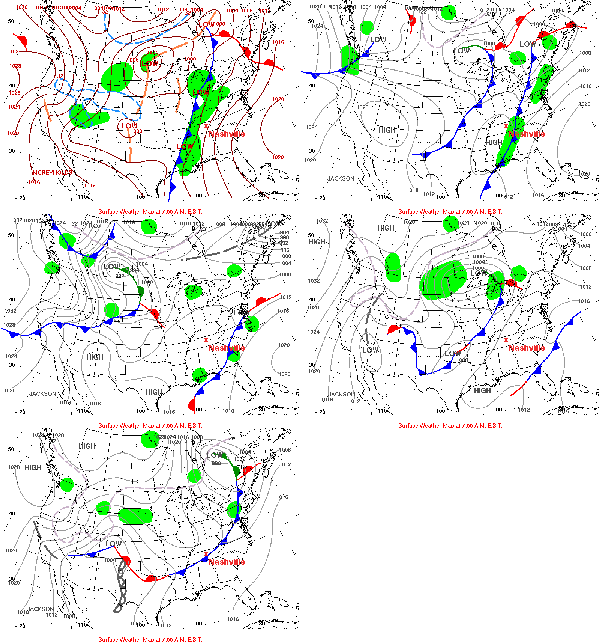
May 2-6 fronts. Animation generated using images from the HPC.

For discussing warm fronts, cold fronts and mid-latitude cyclones, NOAA‘s Hydrometeorological Prediction Center (HPC) is a great resource. You can find an archive of daily weather maps for the U.S. that you can click through to see the fronts move.

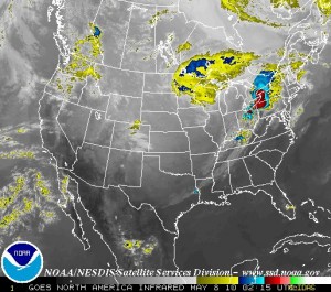
Infra-red satellite image of the continental U.S.. Note the alignment of the clouds and precipitation with the fronts in the first (static) weather map above. (Image from GOES).

Satellite imagery usually complements to the frontal weather maps very well. Most satellites orbit around the Earth pretty quickly, at just the right orbital speed that the centrifugal force just balances the Earth’s gravity so the satellite does not crash into the atmosphere or escape into space. Some satellites are set into orbit a bit further out so that they can rotate with the Earth, effectively staying above the same place all the time. NOAA has a few of these geostationary satellites monitoring the weather around the world, and you can get real-time images from the Geostationary Satellite Server. There used to be archived satellite images but I can’t seem to find them at the moment.

Best nature photos

The Guardian newspaper put together an excellent collection nature photographs for auction for an Earth Day charity. I particularly like the pictures from the Franklin River, south-west Tasmania, Australia and Stone Canyon, Arizona/Utah, U.S.A.. Apart from the wonderful composition and spectacular lighting, I like the effort and meaning behind these images.

Slickrock Formation, Paria Canyon (from Thundafunda). As beautiful as it is, this is not the Stone Canyon photo in the list.

According to the Guardian, the Franklin River image was instrumental in preventing the flooding of the river for an hydroelectric dam. The Stone Canyon picture was used to try to have the area declared a national monument. I particularly appreciate the effort of Jack Dykinga, who took the Stone Canyon photo. He hiked up the slot canyon at 3:30 am in order to get the photograph at dawn; with their softer light and reddish tints, sunrise and sunset are the best times for photography.

Cattle drives

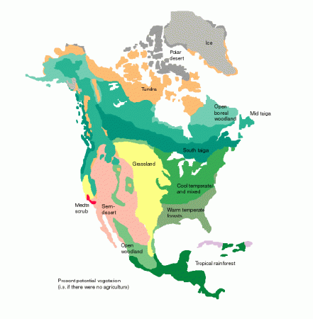
pre-European vegetation of the U.S. (from Oak Ridge National Laboratory).

The story of cattle drives and the railroads also has a lot to do with the geography of natural resources in the United States. A few good references:

Corinth Mississippi in the Civil War

Stream of American History at the Corinth Civil War Interpretive center.

The Memphis to Charleston line was the only railroad that linked the East Coast of the Confederacy to the fertile Mississippi River Valley. At a time when the fastest way to move troops, supplies and commerce was by river or rail, the Memphis and Charleston railroad was essential (this was well noted in Robert Black’s “The Railroads of the Confederacy”). Cutting the railroad was an important objective of the Union. Cutting it at Corinth Mississippi would also cut the Mobile and Ohio Railroad line which linked the north and south of the Confederacy. Thus the Battle of Shiloh, where the Union could disembark its armies using the Tennessee River, and soon after, the Battle of Corinth.

The Civil War Interpretive Center in Corinth (this is also a good reference) does a nice job of presenting the details of the battles for the town, and their video presentation, with different images projected on multiple screens in a circular room was quite good (though there was a lot of information and you did not know quite which screen to focus on, so some students had trouble keeping track of it all).

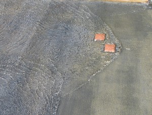
Standing waves: turbulence in the stream of American history.

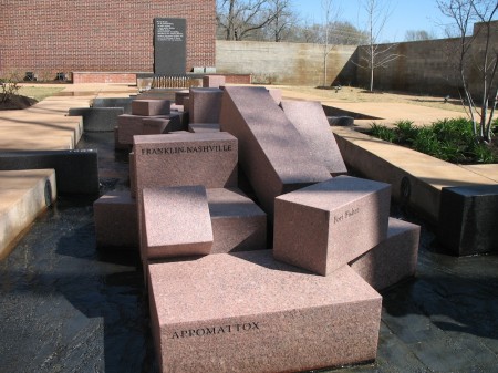
The most interesting part of the center is the Stream of American History which is a wonderful place to learn about metaphors. The stream starts with a fountain that overflows through 13 notches cut in the rim of the basin into a shallow water course that gradually widens as more states are added to the U.S. In the first reach of the stream there are impediments in the paved stream bed that create turbulence, harbingers of the war to come (they create nice standing waves which is an additional point in their benefit).

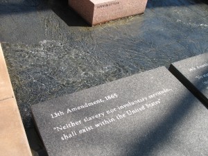
The 13th Amendment.

When the stream gets to its main focus, the civil war, large granitic blocks, cut into prisms and labeled with the names of the battles, break the stream into two before it finally merges again as it reaches the reflecting pool.

I threw my students at the Stream without telling them what it was. The only hint I gave was that it was a “large metaphor”. There were enough clues that they could figure it out. They wandered around it individually, with their pencils and notepaper for 15 minutes (I required that they write down their interpretation, then we got them together to pool their thoughts.

The stream is a very nice puzzle, and the National Park Service has a good key (pdf). It was a good way to end our immersion trip, and it gave the students something to think about on the long drive home.

[googleMap name=”Corinth Civil War Interpretive Center” width=”400″ height=”350″ mapzoom=”4″ mousewheel=”false” directions_to=”false”]501 West Linden Street, Corinth, MS‎[/googleMap]