
Sunrise at about 6:30. When my students woke up I asked them if they wanted to see the sunrise. Then I showed them the picture on the computer.
Middle and High School … from a Montessori Point of View
Sunrise at about 6:30. When my students woke up I asked them if they wanted to see the sunrise. Then I showed them the picture on the computer.

We’re off to Heifer International again with a new crop of middle-schoolers. This time Ms. Vranas is the other chaperone.
With stopping for lunch, stopping for gas, and stopping by a grocery to pick up supplies, the trip out lasted over 8 hours, but we made it out with everyone in good humor. The kids played Head’s Up Seven Up, and their own stashes of snack food.
I use these trips to introduce geology, specifically the dynamics of mountain-building and erosion using the Ozarks as an example. So every time we passed an outcrop (of which there were quite a number) I pointed it out and one of the students would invariably shout out “limestone” (and sometimes it actually was). I’ll actually try to take pictures of the outcrops on the way back when I’m not driving.
After dinners, I usually have the students spend an hour on reflection and discussion. The group gets split in two. While one half writes I discuss something we’ve seen with the other half.
I was planning to talk about the sequence of outcrops tonight, however, the discussion broke in a slightly different direction.
Just after crossing the Arkansas river, I’d asked the students why the land was so flat. It was because we were on the floodplain, but few of them had picked it up. In fact, most of them had not even noticed we’d crossed a fairly large river on a big concrete bridge not 30 seconds before.
So we started talking about why the flood plain is flat, then got on to the erosion of mountains and the deposition of the eroded material on the flood plains and river deltas. The key factor in erosion and deposition is the energy of the stream, which is a function of the slope. This in turn lead us to to talk about the Nile River – as an example -, which lead to the Great Pyramids, and how the fertility of floodplains lead to agriculture and civilization in Egypt, Mesopotamia, Cahokia, and along the Indus. I ended by pointing that most major cities are located on rivers because of their agricultural fertility, and perhaps more importantly today, the utility for transportation.

When the discussions and writing groups broke up, a few started to play Bananagrams, while the rest got a little rowdy. So I pulled them all in again and we talked a little about adolescent development, self-control, and the development of the frontal lobe, as I read them the riot act on proper behavior. It turned into a pretty neat discussion, because they ended up interrogating me about the way I behave toward them: why I always pause a moment before answering even their simplest questions; why I laughed two weeks ago when one of them told me that I was their, “least favorite teacher”; things like that.

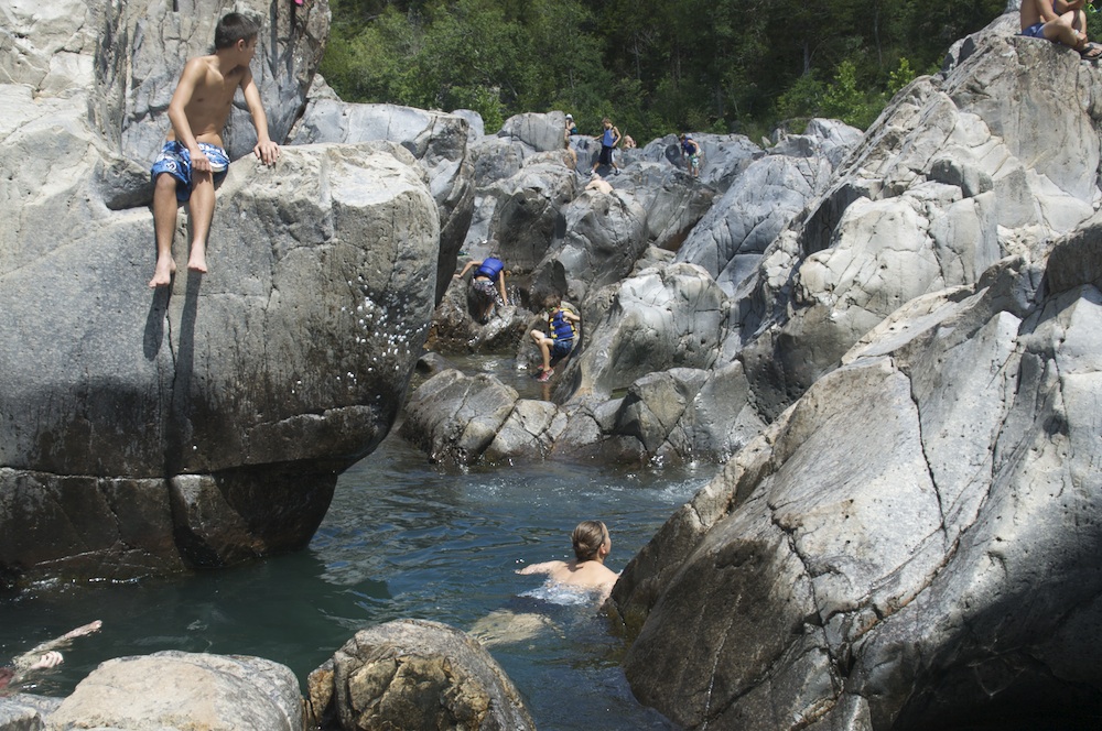
First off, the Shut Ins are narrower constrictions in the river valley formed when stream flows into an area of harder rock. The hard rock, in this case an old (1.5 billion year old) rhyolite flow, is relatively resistant to erosion, especially the side-to-side erosion that flattens out little flood plains as small rivers meander through the foothills of old mountains like the Ozarks. So the stream only erodes downward through the hard rocks creating a narrow gorge. As they say here: the river’s “Shut In”.
When I told people that I wanted to do a few camping trips this summer, the number one recommendation was the Shut Ins. And I can see why. I took my boys and they had an awesome time.
“It’s like the City Museum. Only real.”
— Overheard at Johnson’s Shut Ins
The Shut Ins are a maze of narrow channels, the old igneous rocks carved smooth by the water and its gravelly bed load over millions of years. A great place for kids to traipse through and explore. I bit like a water-park version of the City Museum in St. Louis.


The pattern of the channels is largely determined by the jointing in the rocks, because the joints offer easier pathways for water and erosion. There are at least two obvious sets of joints in the rocks, but I would not be surprised if they overlay other patterns given how old the rocks are. As it is, however, the erosion through the joints creates lots of neat little chutes.

Since the Shut Ins are only a couple hours away from St. Louis, they’re a pretty popular tourist attraction.
There’s a lot of science that can be done here, however, that would make this a good location for an immersion trip, especially since Elephant Hills State Park (with wonderful spheroidal weathering) is close by. The camping facilities at the Shut Ins State Park are new and quite nice, having been completely rebuilt with some of the $100 million in settlement money from the Ameren power company after the park was flooded by their Taum Sauk reservoir breach in 2005.
It’s certainly worth the visit.


I had my pre-Calculus students take pictures of curves at the City Museum. Ms. Wilson’s geometry students had to photograph shapes and angles instead. Then they had to put together a slideshow of what they found, which, from what I heard, went very well.

Despite choosing to traipse through the prairie while geocaching, my students’ only encounters with fauna were along and on the side of the road.
Now, I tend to be terrible at identifying animals, but only last week I ran into an eastern garter snake so I actually knew something about this meter-long specimen that was stepped on by one of my students while she was running back to the Audubon Center. I convinced the group to leave it alone since these snakes do bite — even though they’re not poisonous — and release a bad-smelling odor when threatened. And this guy was somewhat traumatized.
As for the student. She was somewhat traumatized too, but got over it soon enough. I think she was more put out by the fact that when she told her mom about it that night, her mom’s first response was, “That poor snake.”

The size of the reddish-brown band on wooly bear caterpillars, Pyrrharctia isabella, is supposed to predict the severity of the winter. A wider band the milder the winter.
This specimen, rescued off the road next to the Audubon Center on the road to Confluence State Park, seems to suggest a mild winter.


I asked my students to take pictures of the curves they found while on our field trip to the scrap metal playground that is the City Museum. The plan is to see if we can determine what functions best fit the curves. To do so, we need to transfer the curves from the images to a co-ordinate system. Since I’m primarily interested in what type of functions might best fit the data, the scale of the co-ordinates does not matter that much.
Feet, inches, meters, centimeters, pixels, or any other units can be used. In fact, I use a purely arbitrary set of coordinates in the image above. All I require is that the grid be evenly spaced (although the vertical and horizontal spacing don’t have to be the same, it’s more straightforward if they are).
Now we take a set of points that lie on our shape and try to match them to some sort of curve using a spreadsheet, and, if we’re able, least squares regression.
There were lots of shapes to choose from.
