Carefully supervising the sawing of a log. You can just make out the spinning saw blade slicing through the far side of the log.
A couple weekends ago, I took my kids to see the Deutsch Country Days. It’s one weekend each year where they set up a 19th century German immigrant village in Marthasville just east of St. Louis. They make cider, cheese, candles, rope, tin ornaments, and a lot more on the spot. You can see the wonderful household mechanisms in old log cabins and watch blacksmiths at work. But my favorite part had to be the sawmill where they were cutting large logs using a large, ~75cm, diameter blade powered by an actual steam engine.
The boiler for the steam engine.
The big boiler pipes steam into the engine which turns a wheel and axle, which drives a large belt, which connects via another wheel and axle to the large blade. It’s a nice example of a complex machine, which the middle schoolers have been discussing in class.
The steam engine. The rate at which it spins is controlled by a centrifugal governor (the red balls), which is quite an elegant device. The engine turns the large red wheels which are connected to the blade via a long belt.Sharpening the blade.
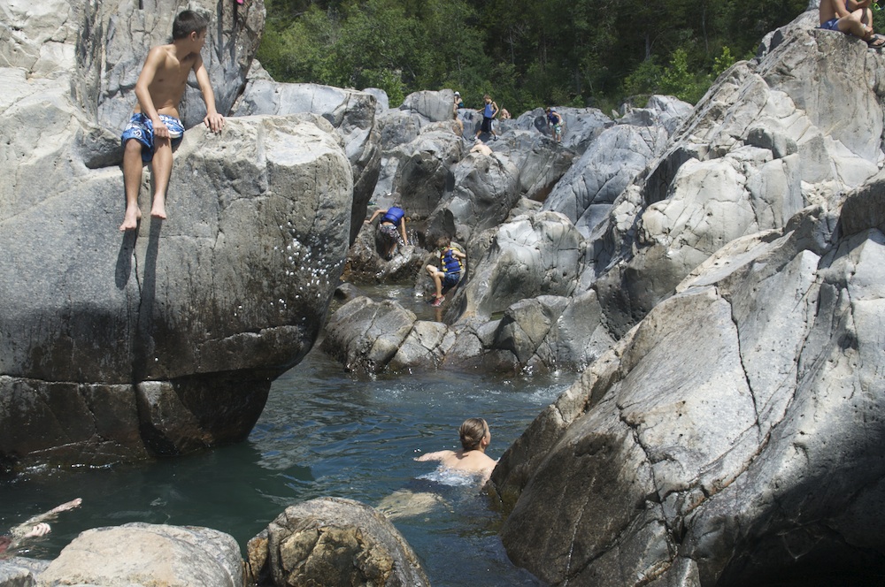
Exploring the natural water works at the Johnson’s Shut Ins.
First off, the Shut Ins are narrower constrictions in the river valley formed when stream flows into an area of harder rock. The hard rock, in this case an old (1.5 billion year old) rhyolite flow, is relatively resistant to erosion, especially the side-to-side erosion that flattens out little flood plains as small rivers meander through the foothills of old mountains like the Ozarks. So the stream only erodes downward through the hard rocks creating a narrow gorge. As they say here: the river’s “Shut In”.
When I told people that I wanted to do a few camping trips this summer, the number one recommendation was the Shut Ins. And I can see why. I took my boys and they had an awesome time.
“It’s like the City Museum. Only real.”
— Overheard at Johnson’s Shut Ins
The Shut Ins are a maze of narrow channels, the old igneous rocks carved smooth by the water and its gravelly bed load over millions of years. A great place for kids to traipse through and explore. I bit like a water-park version of the City Museum in St. Louis.
Rushing water in a shallow channel leads to a deeper pool.Looking down from the cliffs above the Shut Ins, the sets of linear joints in the rocks are quite clear.
The pattern of the channels is largely determined by the jointing in the rocks, because the joints offer easier pathways for water and erosion. There are at least two obvious sets of joints in the rocks, but I would not be surprised if they overlay other patterns given how old the rocks are. As it is, however, the erosion through the joints creates lots of neat little chutes.
Looking along a narrow eroded joint.
Since the Shut Ins are only a couple hours away from St. Louis, they’re a pretty popular tourist attraction.
Population density is high.
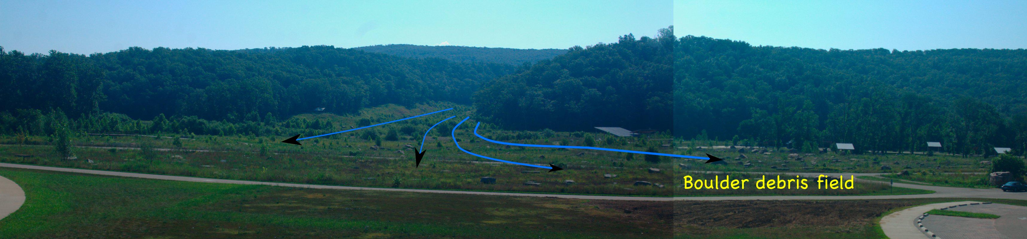
There’s a lot of science that can be done here, however, that would make this a good location for an immersion trip, especially since Elephant Hills State Park (with wonderful spheroidal weathering) is close by. The camping facilities at the Shut Ins State Park are new and quite nice, having been completely rebuilt with some of the $100 million in settlement money from the Ameren power company after the park was flooded by their Taum Sauk reservoir breach in 2005.
The path of the wave from the Taum Sauk reservoir breach created a debris field with huge boulders, and demolished the original Johnson’s Shut Ins campground. The Shut Ins themselves are downstream to the right.
It’s certainly worth the visit.
As the stream exits the Shut Ins it has dredged some excellent swimming pools.
The slide on the third floor of the City Museum. A co-ordinate system is overlayed, and points showing the curve of the slide are selected.Elegant curves.
I asked my students to take pictures of the curves they found while on our field trip to the scrap metal playground that is the City Museum. The plan is to see if we can determine what functions best fit the curves. To do so, we need to transfer the curves from the images to a co-ordinate system. Since I’m primarily interested in what type of functions might best fit the data, the scale of the co-ordinates does not matter that much.
Feet, inches, meters, centimeters, pixels, or any other units can be used. In fact, I use a purely arbitrary set of coordinates in the image above. All I require is that the grid be evenly spaced (although the vertical and horizontal spacing don’t have to be the same, it’s more straightforward if they are).
Now we take a set of points that lie on our shape and try to match them to some sort of curve using a spreadsheet, and, if we’re able, least squares regression.
There were lots of shapes to choose from.
There were lots of shapes to choose from, including the nice sinusoid in the background.
I took a half-day trip during spring break (somewhere around the 31st) to the Shaw Nature Reserve in Gray Summit. I was hoping to find some books on native, Missouri, flora and fauna, and see if the Reserve would be a good place for a field trip (they have sleeping facilities so even overnight trips are a possibility).
I found a number of books, including a nice one on mushrooms, and while I could have, I did not pick up one on wildflowers (of which there were several). Of course, spring is the perfect time to see wildflowers, especially since we ended up hiking the Wildflower Trail, so I’m probably going to have to go back sometime soon.
The lady at the main office (where you pay $5/adult) recommended we take the Wildflower Trail and then cut down south to the sandbar on the Meramec River, which is an excellent place for skipping rocks. She also recommended I take my two kids to their outdoor “classroom” for some real, unstructured play.
Without a reference book, I’ve had to resort to the web for identifications, with only a little success, so I’ll post a few of my photographs here and update as I identify them.
The following two pictures are of a flower that was found covering the hillslope meadows; open areas with short grass.
Beautiful reddish-orange blooms on this small herb.This picture better captures the growth form and leaves of this hillslope, meadow flower.A yellow petalled variant.
Like little stars in the daylight, these small, white flowers meadow flowers almost sparkle.
Small, white, meadow flowers.
Pretty, small, yellow, meadow flowers.
Yellow, meadow flowers.
These bent-over flowers can be found on the lower, shadier edges of the hillslope meadows.
These guys like the shadier areas.I love the texture of the charred wooden stump behind the flower. The meadow itself is possibly the result of a burn.
Iris’ were also in bloom.
Small iris.
Another herbaceous, yellow flower.
Pretty yellow flowers.
More, tiny, delicate flowers.
Found in the shadier, moister parts of of the slope.
Once you get under the canopy, you run into some broader leaved plants and their own, interesting flowers.
Bell-shaped flowers in broad-leaved herbs/shrubs.
We ended up spending a lot of time on the sandbar, learning to skip rocks and hunting for clams, but I save that for another post. And we never did get to the play area; that’ll have to wait for the next trip.
A discussion of the physics of flight, interspersed with birds of prey swooping just centimeters from the tops of your head, made for a captivating presentation on avian aerodynamics by the people at the World Bird Sanctuary that’s just west of St. Louis.
Lift
The presentation started with the forces involved in flight (thrust, lift, drag and gravity). In particular, they focused on lift, talking about the shape of the wings and how airfoils work: the air moves faster over the top of the wind, reducing the air pressure at the top, generating lift.
The shape of a bird's wing, and its angle to the horizontal, generates lift. Image adapted from Wikipedia User:Kraaiennest.
Then we had a demonstration of wings in flight.
Terror from the air.
We met a kestrel, one of the fastest birds, and one of the few birds of prey that can hover.
Kestrel.
Next was a barn owl. They’re getting pretty rare in the mid-continent because we’re losing all the barns.
Barn owl.
Interestingly, barn owls’ excellent night vision comes from very good optics of their eyes, but does not extend into the infrared wavelenghts.
Barn owl in flight.
Finally, we met a vulture, and learned: why they have no feathers on their heads (internal organs, like hearts and livers, are tasty); about their ability to projectile vomit (for defense); and their use of thermal convection for flying.
The ground warms when it absorbs sunlight (e.g. parking lots in summer) and in turn warm the air near the ground. Hot air rises, creating a convection current, or thermal, that the vultures use to gain height.
The Sanctuary does a great presentation, that really worth the visit.
Nympheas, by Claude Monet. Image via Wikipedia.
We took the middle and high school to see the Monet Water Lilies exhibit at the St. Louis Art Museum today. It was a nice tour; we saw some paintings, and we learned a little something about the impressionists.
One thought that occurred to me during an interesting conversation on the bus back to school, was how the development of abstract thinking skills affects our perception of the more abstract art. After all, it usually requires more effort to appreciate, understand and become affected a piece the more abstract it is. Which would suggest that art appreciation would be useful practice for adolescents who are honing their higher-level cognitive skills.
The tour also left me with one unanswered question, however: are we seeing fog or smog in Monet’s painting of the Charing Cross Bridge in London.
Charing Cross Bridge by Monet. Image via Wikipedia.
London is famous for its fogs, but this painting was done in 1899, well into the industrial revolution, and the yellow tints suggest a pea-souper.
The iron gets into the water when pyrite crystals (FeS2) in the coal dissolves. While the iron precipitates, the sulfur remains in the water, making it more acidic. Dealing with the acid can be a huge problem in large coal and metal mines.
The pool of water that collects at the base of the quarry, is probably fairly acidic.
Not all the pyrite is dissolved however, and since this particular coal seam has a lot of pyrite, it is not economical to burn since the burnt sulfur (as sulfur dioxide gas) would have to be captured — otherwise it produces acid rain.
The rich black coal seam sits on top of blocky limestone rock. Above the limestone is a red, weathered soil.
We discussed quite a variety of topics just based on the visit to the landfill/quarry.
A single, half-day, visit to the landfill and quarry brought up quite the variety of topics, ranging from the quarry itself, to the reason for the red colors of the cliff walls, to the uses of the gases that come out of the landfill. I still have not gotten to the details about the landfill itself, but I’ve put together a page that links all my posts about the quarry and landfill so far.