Mapping America: Interactive Census Data Maps

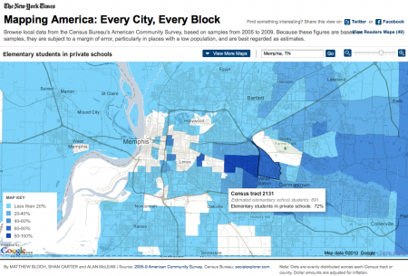
The number of elementary students in private schools in the Memphis area. Image from the New York Times' Mapping America project.

The New York Times has made data from the U.S. census available in an interactive map. This is an excellent tool to play with, since it has geographic information about income, race, education and more. The data is at the census tract level, so it is quite detailed.

I can see using this app being very useful for local research projects. Simply comparing the location of the different racial populations in a city like Memphis to the spatial distribution of income or education would probably tell a lot that we already intuitively know.

North American English Dialects

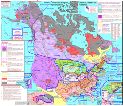
Link to map of Rick Aschmann's American English Dialects

Linguist, Rick Aschmann, has wonderfully detailed maps of the various dialects of English used in North America. It includes lots of audio samples of speech, and is excellently annotated.

Given that dialects are great integrators of cultural history, including the history of immigration to the different regions, this may well be an excellent resource for this cycle’s work on U.S. immigration.

The r-dropping areas in the Lowland South … could be described as “Classical Southern”. This is the accent that Scarlett O’Hara is attempting to imitate in this clip from Gone with the Wind. This area represents the heart of the old plantation system, as can be seen on the map mentioned above. However, this feature seems to only occur in older settled areas, and does not occur in western areas on the Mississippi River or farther west that were settled after about 1825.
— from American English Dialects by Aschmann, (2010).

Voyage of the Beagle

Wired has a brief but excellent article on the voyage of the Beagle.

Its goal was to survey the South American coastline. The captain invited along a young man named Charles Darwin, whose father thought the voyage would just be another excuse for him to slack off. The trip ended up taking five years.

This article would be a wonderful addition to our work on exploration of the Americas next time it comes around; however, it’ll also be a neat little footnote because we’ll be delving into evolution next cycle.

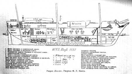
Wikipedia’s entry on the ship produced this wonderful cross-section. I particularly like the sketches of people and casks showing the use of of different cabins and spaces.

Cross-section through the HMS Beagle.

Global Warming update

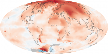
Global temperature difference (anomoly) of 2000-2009 compared to 1950-1980.

NASA’s Earth Observatory is not only a great place for pictures from space, it also posts regular scientific updates, including the most recent map of the change in temperature since 1980.

The most obvious observation from the map is that the poles are warming faster than the rest of the planet, especially the North Pole. This is a pattern that has been predicted since at least the 90’s, so the temperature observations tend to show that the scientists and computer modelers who do this research may just know what they’re doing.

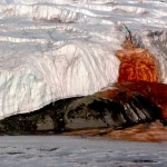
Blood Falls, Antarctica. Note the tent in the lower left for scale. From the U.S. Antarctic Program.

It’s also important to note that the Antarctic is not warming nearly as fast as the Arctic. The continental glaciers that would most significantly raise sea level (think 10’s of meters) are in Antarctica.

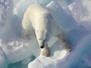
Image from the USGS.

The northern hemisphere warming will likely be difficult for a number of species to deal with. Polar bears, the charismatic megafauna (I love that term) most associated with the effects of the melting Arctic sea-ice, are still in big trouble. Recent research, however, suggests that if something can be done to reduce global warming in the coming century, there will remain places with enough ice that the species may survive.

Update: Interesting article on global warming science and politics in the NY Times. It starts off talking about David Keeling, the scientist who came up with a reliable way to measure atmospheric carbon dioxide.

Visuwords: a visual dictionary

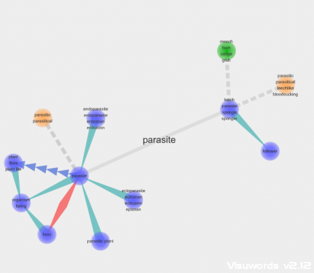
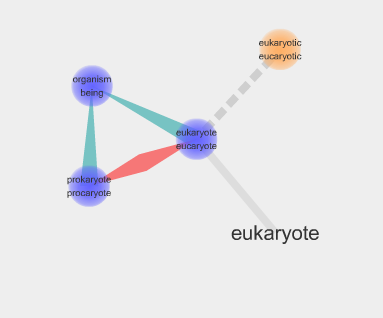
The definition of parasite on Visuwords.

Visuwords is a great visual dictionary. It not only gives definitions, but shows the links between antonyms, synonyms and etymology.

I plugged in a few of the words from this cycle’s vocabulary lists (parasite, circumnavigate, host, viceroy etc.) and the results were quite neat.

Also, if you double click a word/node it expands to show you the things it’s connected to. This can lead to a quite complex diagram. It would have been great to use it for the word navigator, because it gives a graphic organizer that pretty much covers what we talked about for social world this cycle.

Definition of eukaryote. Notice it links to the word prokaryote (the red line indicates that it's an antonym).

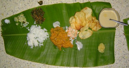
Banana leaf plates

(Image by Pamri on Wikimedia Commons)

This one takes me back to the days when I was growing up and going to weddings and Hindu prayers ceremonies at someone’s house. There’d be food, with curry chicken, dhal, buss-up-shot roti, served on banana leaves. Oh … the smell and the taste. I unreservedly endorse using them for serving food; they’re biodegradable and seem to add something to the flavor. Long-term packaging I’m not so sure about, but you never know.

Perusing Wikileaks’ Cables

Wikileaks’ recent leak of U.S. State Department cables offers the student with a politics/geography interest an amazing glance into the role of U.S. diplomats. There are however, a lot of cables.

The Atlantic magazine has come up with an interesting way of perusing the information. Their Cablegate Roulette webpage puts up a random cable every time you press the “Load a new story” button.

What’s also nice is that they provide a sentence or two that gives the context of the cable so you don’t have to puzzle it out on your own.

The cable excerpts are brief, well written and quite informative about the political goings-on in different parts of the world. They could make an interesting supplement to the geography curriculum. The self-motivated student with a geography interest would find these quite fascinating because you have to have a basic knowledge of the world and recent history to understand what’s going on.

An example:

An executive with Kazakhstan’s national gas company has dinner with the U.S. ambassador at the Radisson hotel in Astana, the capital of Kazakhstan.

FROM: ASTANA, KAZAKHSTAN
TO: STATE DEPARTMENT
DATE: JANUARY 10, 2010
CLASSIFICATION: SECRET
SEE FULL CABLE

¶7. (S) The Ambassador asked if the corruption and infighting are worse now than before. Idenov paused, thought, and then replied, “No, not really. It’s business as usual.” Idenov brushed off a question if the current maneuverings are part of a succession struggle. “Of course not. It’s too early for that. As it’s always been, it’s about big money. Capitalism — you call it market economy — means huge money. Listen, almost everyone at the top is confused. They’re confused by their Soviet mentality. They’re confused by the corrupt excesses of capitalism. ‘If Goldman Sachs executives can make $50 million a year and then run America’s economy in Washington, what’s so different about what we do?’ they ask.”