Chinese exploration

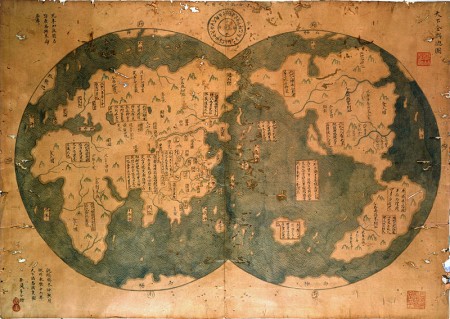
Controversial map purporting to be based on an earlier 1418 map of Chinese exploration of the world. Image from Wikimedia Commons.

Most of the exploration we studied this cycle were European expeditions. One group wanted to do something a little different, so I suggested they look in to Chinese explorations of other parts of the world. There was much Chinese commerce across the Indian Ocean, and in a non-Christian twist on the “God” theme for exploration, the Chinese brought Buddhism back from India in the third century AD (we’re studying exploration under the themes of God, Gold and Glory).

Another interesting aspect of research into Chinese exploration is the rather controversial work by Gavin Menzies that suggests that great Chinese fleets explored the Americas and circumnavigated the globe in the 1420’s, a long time before Columbus and Magellan.

There is a lot of evidence that there was no such Chinese expedition, but it’s a fascinating hypothesis and, in a way, very similar to the All About Explorers project: although Menzies’ work is not an intentionally educational hoax. Indeed, it is much more subtle and much more detailed. My favorite line of critique asserts that Menzies’ books, “.. may well prove to be the Piltdown Man of literature.” I don’t know if I’ll have the time to try to unpack that one for my students.
Northwest Passage

The poignancy and romance of exploration are distilled in Stan Rogers’ ballard “Northwest Passage“.

Ah, for just one time I would take the Northwest Passage,
To find the hand of Franklin reaching for the Beaufort Sea;
Tracing one warm line through a land so wild and savage
And make a Northwest Passage to the sea.
–Stan Rogers (1981) from Northwest Passage.

The Bounding Main website has the lyrics, including footnotes about Franklin and the others mentioned in the song, as well as major geographic features like the Davis Strait and the Beaufort Sea.

History and art collide. The music sticks in the brain then seeps down to catch the throat. I think this is a great way to get into (spark the imagination about) Artic exploration.

The next step is, of course, Shackleton and The Endurance.

Exploration of the North American Coastline

This wonderful animation shows the exploration of the North American Coastline from 1500 to 1876, updating the map as the different explorers push further along the coastline. Most of the action occurs to the north, as expedition after expedition sough the Northwest Passage.

What’s nice, is that the names of the explorers, like Cabot and Franklin, should be familiar to students after this cycle’s research.

Mariner AO: Discovering the Americas

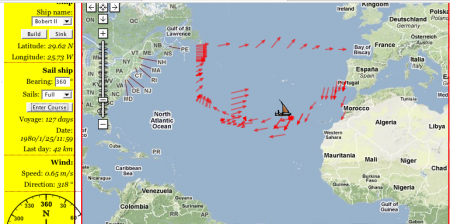
The route of the good ship Bobert II.

We just used my sailing game, Mariner AO, to help wrap up the group presentations on the European exploration of the Americas, and it worked wonderfully!

The small groups did their presentations timewise, starting with the Vikings (don’t ask me about Leprechauns), then the Spanish, the French (don’t ask me about giant sharks and flying pigs), and finally the English. At the end, we had half an hour left, but instead of just tying it together with a graphic organizer, I wanted to show them Mariner AO because the North Atlantic wind circulation ties in so wonderfully well with the pattern of colonization.

I started trying to show it off as a group, having them tell me which direction to sail the ship to get to the Americas. As you could probably predict that didn’t work particularly well. Everyone was yelling out directions at cross-purposes; however, it did give me the chance to show them all how the game worked.

Even with all the confusion the group seemed to like the game. Someone even suggested, “Why didn’t we do this for group work.” And I though, “Why not?” So the class broke apart for 25 minutes to see who could discover America first.

There was a lot of excitement in the room. I offered them extra points for the team that reached America first. They all know how empty that reward is by now so I think most of the excitement really came from being able to play a game with a little bit of competition.

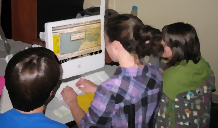
Building a ship to try to discover America.

The website still has a few bugs, especially on our older computers, but it worked. Three of the four groups reached the Americas, though two of them landed on the Canadian coast. The third group may well have ended up there as well, but I dropped a hint about Columbus’ route that sent them sailing into the Caribbean.

At least two kids planned on trying it at home. I had to pry one of the groups away from the computer so they could get their end-of-the-day jobs done on time.

We took screen captures of routes they took, and tomorrow we’ll put it all together, talk about the trade winds, what Columbus knew, and why the Iberians colonized South America while the French and English ended up mostly in the North.

NationMaster: Geographic statistics

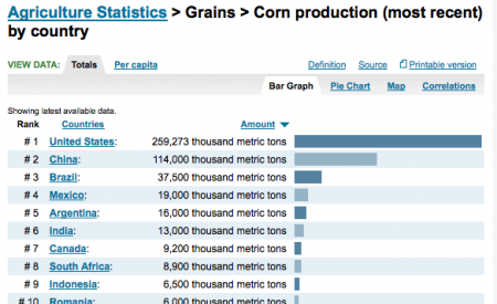
Graph of corn production from NationMaster.

One of my students, Ben, discovered NationMaster.com while looking up statistics for corn production as part of his small group’s work on seeds of change. It seems to be a wonderful source for economic and geographic statistics. From their site:

[NationMaster is] a massive central data source and a handy way to graphically compare nations … a vast compilation of data from such sources as the CIA World Factbook, UN, and OECD. Using the form above, you can generate maps and graphs on all kinds of statistics with ease.

Interesting fact: China is the second largest producer of corn in the world.

Saudade

Saudade:
Pronunciation: (from Forvo)
Definition: Portuguese – One of the most beautiful of all words, translatable or not, this word “refers to the feeling of longing for something or someone that you love and which is lost.” Fado music, a type of mournful singing, relates to saudade. (from Jason Wire at MatadorNetwork)

The beauty of the words in Jason Wire’s list, “20 Awesomely Untranslatable Words from Around the World” is that they express somewhat complex emotional concepts.

Last week I had to explain the English word, nostalgia. Its meaning was a little difficult to convey because, when you think about it, to feel nostalgic you need to have had a certain amount of self-reflection. Self-reflection is typically not a strong point of early adolescence, which is why we have Personal World every day.

Then I came across Jason Wire’s list, and there are some wonderful words on there, but the one that resonates right now is the Portuguese “saudade”. I like how it is subtly different from nostalgia, but I also like that there is an entire genre of music, fado, that embodies the word.

NPR has a great review of fado artist, Ana Moura:

Also, in looking up the pronunciation of the word I came across the Forvo website. It has recordings of people saying words from around the world, so you can hear the sounds of words from native speakers. I chose the one in this post, a female Portuguese voice (), because it seems to capture the poignant emotion of the word quite well.

Geography of Hot Springs, AK

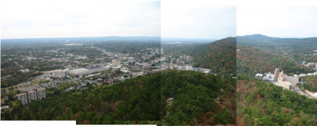
The overlook tower in Hot Springs is a bit expensive ($7 a pop.) but offers a great view of the town and a great place to observe somewhere with the themes of geography in mind.

Hot Springs, AK.

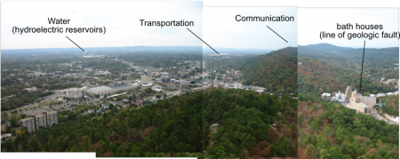
Our bi-annual trip to Little Rock and environs could easily include a stop in Hot Springs. I swung by the Hot Springs National Park there last weekend and really liked the potential of the observation tower as a place to tie in the themes of geography. The town is small enough that you can see it all, including the reservoirs supplying it with water, from the tower. It’s something to consider.

I’ve also just noticed that the National Park Service has, on their Teachers page, a two for one deal where you can visit the Hot Springs National Park and Central High School and have your costs reimbursed. I’m pretty sure, however, that this does not include the tower.

A few things you can see.

Erosion as diffusion

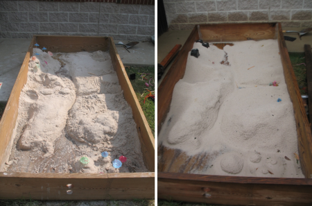
Landforms in the sandbox before and after the rain.

We left the sandbox uncovered under last week’s heavy rain, and the result was a new perspective on erosion, sedimentation and the evolution of landforms.

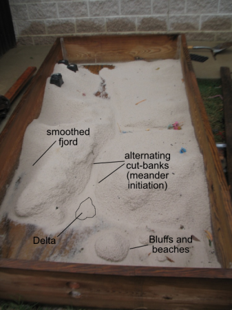
Nice, sharp, hand-sculpted valleys were smoothed out by the raindrop splatters. The beautifully steep sided fjord on the lower left, in particular, eroded into the gentler slopes of a fluvial surface.

This process is diffusional. Sand moves from high peaks to fill in the low valley floors, evolving toward a softer, flatter land surface in the same way dye in pan diffuses from the high concentration droplet to a more uniform distribution.

There was enough rain that water pooled, for a little while, at the lower end of the sandbox. This allowed the formation of a beautiful little delta from the main river, which was most remarkable to observe while it was raining because the channel bifurcated at its mouth with running water to the left and right of the depositional landform.

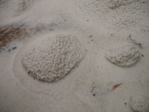
Island bluffs surrounded by sandy beaches.

The standing water in the “ocean” also caused the islands to partially erode at the edges to create steep bluffs overlooking sandy beaches.

And finally, if you looked carefully at the sides of the river channel you could see where the water was beginning to cut into the banks, a little offset on either side, to start the formation of meanders.

Annotated sandbox features.