Voyage of the Beagle

Wired has a brief but excellent article on the voyage of the Beagle.

Its goal was to survey the South American coastline. The captain invited along a young man named Charles Darwin, whose father thought the voyage would just be another excuse for him to slack off. The trip ended up taking five years.

This article would be a wonderful addition to our work on exploration of the Americas next time it comes around; however, it’ll also be a neat little footnote because we’ll be delving into evolution next cycle.

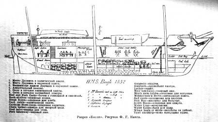
Wikipedia’s entry on the ship produced this wonderful cross-section. I particularly like the sketches of people and casks showing the use of of different cabins and spaces.

Cross-section through the HMS Beagle.

Perusing Wikileaks’ Cables

Wikileaks’ recent leak of U.S. State Department cables offers the student with a politics/geography interest an amazing glance into the role of U.S. diplomats. There are however, a lot of cables.

The Atlantic magazine has come up with an interesting way of perusing the information. Their Cablegate Roulette webpage puts up a random cable every time you press the “Load a new story” button.

What’s also nice is that they provide a sentence or two that gives the context of the cable so you don’t have to puzzle it out on your own.

The cable excerpts are brief, well written and quite informative about the political goings-on in different parts of the world. They could make an interesting supplement to the geography curriculum. The self-motivated student with a geography interest would find these quite fascinating because you have to have a basic knowledge of the world and recent history to understand what’s going on.

An example:

An executive with Kazakhstan’s national gas company has dinner with the U.S. ambassador at the Radisson hotel in Astana, the capital of Kazakhstan.

FROM: ASTANA, KAZAKHSTAN
TO: STATE DEPARTMENT
DATE: JANUARY 10, 2010
CLASSIFICATION: SECRET
SEE FULL CABLE

ΒΆ7. (S) The Ambassador asked if the corruption and infighting are worse now than before. Idenov paused, thought, and then replied, “No, not really. It’s business as usual.” Idenov brushed off a question if the current maneuverings are part of a succession struggle. “Of course not. It’s too early for that. As it’s always been, it’s about big money. Capitalism — you call it market economy — means huge money. Listen, almost everyone at the top is confused. They’re confused by their Soviet mentality. They’re confused by the corrupt excesses of capitalism. ‘If Goldman Sachs executives can make $50 million a year and then run America’s economy in Washington, what’s so different about what we do?’ they ask.”
Water for life; for civilization

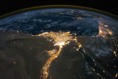
The Nile and its delta (image from NASA).

This nighttime photograph of the Nile River and its delta from the International Space Station beautifully illustrate the importance of water for life and civilization. The city of Cairo is at the neck of the delta; the brighter spot where the distributaries diverge.

Spaceflight Now has other really cool photos. Bad Astronomy has an interesting post on the logistics of this particular photo, while Heather Pringle has a very interesting post on how the desert may have aided the ancient Egyptian’s civilization.

Rearranging the map

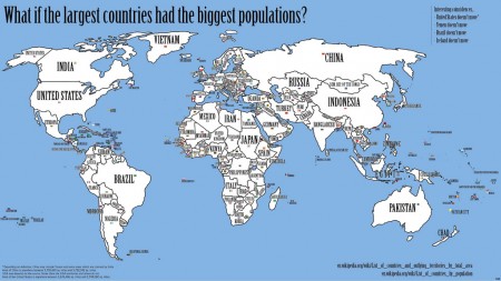
What if you exchanged countries based on population for land area? So China, which is the most populous country would take the place of Russia, which has the largest area. It would create the intriguing map below (from the wonderful blog, Strange Maps).

World Map if the largest countries had the biggest populations. Map by Frank Jacobs.

Letter from a dying explorer

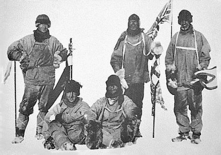
While discussing polar exploration, I mentioned the story of Amundsen and Scott’s race for the south pole. The fascinating blog, Letters of Note, has Scott’s last letter, written bit by bit, on the ice, to his wife back home. It starts, “To: my widow.”

Photograph of Scott's (far left) expedition at the South Pole, on 17 January 1912, the day after they discovered Amundsen had reached the pole first. (Photo via Wikimedia Commons)

P.S. Letters of Note is a great resource for examples of great letter writing.

Artistic satellite views of the Earth

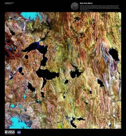
The Tibetian Plateau. Image from the satellite Landsat 5 via the Eros Image Gallery.

For the geography nerds, but perhaps also for those with an appreciation of the natural beauty of the world. The US Geological Survey has a series of satellite pictures chosen just for their sheer beauty.

The Landsat satellites that take these pictures usually photograph in more than just the human-visible color spectrum. For many geologic and environmental purposes, different infra-red wavelengths are often better for seeing details on the Earth’s surface. The USGS has a nice primer on the Landsat program. Many of the color images posted here were reconstructed from different color bands.

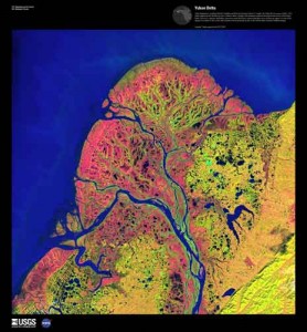
Yukon delta. Image from Landsat 7: Earth as Art 3 collection.

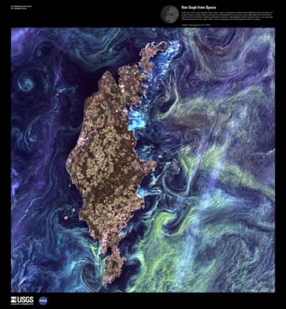
The resulting images can be exceptionally beautiful and somewhat surreal. I like that there is an abstract surface beauty, divorced from the content, meaning and understanding that a closer analysis of the images yields to the eye of the trained observer: delicate swirls of algae might be signs of eutrophication to a biologist; dendritic deltas tell the geologist about sediment load, offshore currents and mass balance.

Phytoplankton bloom around the Swedish island of Gotland in the Baltic Sea is reminiscent of Van Gogh's Starry Night. Image from Landsat 7.