Mushroom Hunting: A Biological Survey of the Campus

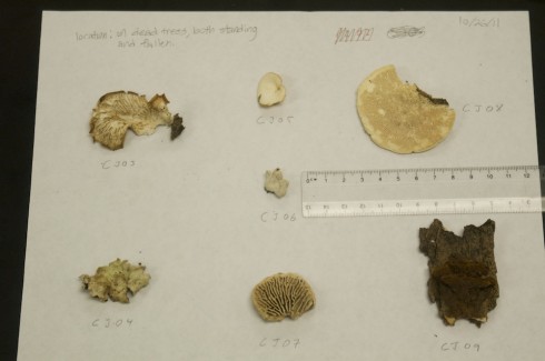
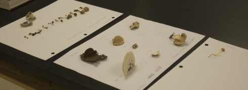
A selection of (as yet) unidentified fungi from the school campus in eastern Missouri.

It’s remarkable how interest drives motivation and motivation gets things done. We’re in an intercession right now and ten students signed up with me to do a biological survey of the school grounds. With a small creek on one side, and a fairly tall ridge on the other, the school has a nice variety of biomes.

Now, to be clear, I’m not a biologist. In fact, that’s why I was so interested in the biological survey. Everything in this area is new to me. But it also means that I approached this project as a novice. Mrs. E. was nice enough to lend me a veritable library of reference books, covering everything from the wildflowers of Missouri to the amphibians of the mid-West, but she was off teaching another batch of students how to cook, so I was on my own.

All the students in the group were volunteers, but a fair chunk of them just wanted to get outside, even though it was overcast and threatening rain. To get the students more engaged I let them choose either the environment they’d like to survey, or the types of organisms they’d like to specialize in. I also gave them the option of working independently or in pairs.

The Creek
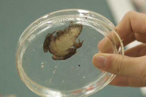
The Creek team collected a pair of amphibians. They were documented, photographed, and then released.

One pair choose to canvas the small creek that runs past the school. I’d set a minnow trap the night before to collect fish for our tank, and they hauled that in. The stream water was somewhere around 14°C, while our tank was closer to 23°C, so, to prevent the fish from going into thermal shock, we left the minnows in a bucket so it could, slowly, thermally equilibrate. They monitored the temperature change with time, and I think I’ll use their data in my physics and calculus classes.

They also collected a pair of amphibians, which we photographed and then released. They tried to catch some crawfish, but were unsuccessful, despite the fact that one of them searched for “how to catch crawfish” on their phone; unfortunately they did not have time to follow the detailed video instructions they found on the web that described, in detail, how to build a crawfish trap.

Trees and Shrubs
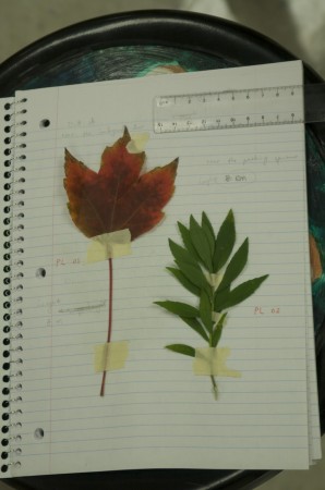
Collected leaf specimens PL01 and PL02.

Because of the incipient rain, we did not take our reference books out with us. Instead, we collected leaves and sketched bark patterns so we could do our floral identification later.
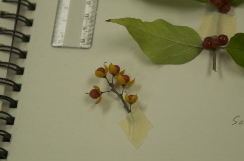
Berries from an (as yet) unidentified bush.

A number of students really got into that. So we have a fairly large collection, though almost all of which come from the riparian area that bounds the creek. I would have liked a broader survey, but we only had so much time.
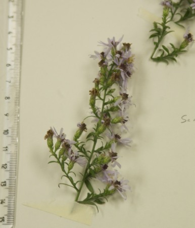
Unidentified wildflowers.

Mushrooms

Part of our mushroom collection.

More than a few students were interested in looking for mushrooms – even one of the tree specialists came back a mushroom sample – but one student really got into it, canvasing all the dead logs from the creek, through the meadow, and up past the treeline on the side of the hill.
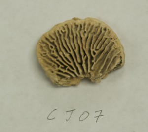
The underside of this fungi looks a bit like a brain coral.

And we now have quite the collection of fungi. They’re as yet unidentified, but they’re elegant bits of biota. Our fungi specialist is interested in coming back in and sketching them.

Identification

We had two hours. Not even enough time to do a complete survey, so we barely got started on identification. It will probably go slowly.

While our methods were not systematic, and our coverage of the grounds incomplete, this exercise was a good start to cataloging the local biology. I don’t know if I’ll be able to expand on the survey any time soon, but this type of project would be a great for middle school science next year when we focus more on the biological sciences, particularly on taxonomy.

Nearby Coal Plant’s Leaking Coal Ash Pond


View Ameren’s Coal Power Plant in a larger map

Jeffery Tomich had a good article last month on the leakage from the coal ash pond at a coal burning power plant near to our school. While the leakage appears to pose no real risk to us, it is a serious environmental issue at a local site that a number of students drive by on the way to school.

I’ve annotated the following excerpt from the article based on the questions my students asked when we talked about the it.

Since Since 1992, a coal ash pond next to the Ameren power plant here has been … hemorrhaging up to 35 gallons a minute [into the local groundwater].

At many [other] sites, trace metals in coal ash including lead, mercury, arsenic and selenium have been found in groundwater at levels that exceed drinking water standards.

In 2007, a U.S. Environmental Protection Agency report identified 63 sites in 26 states where the water was contaminated by heavy metals from coal ash dumps. That was more than a year before an estimated 5.4 million cubic yards of coal ash sludge escaped an impoundment in Kingston, Tenn. The sludge spread across 300 acres, and 3 million cubic yards spilled into a river.

The waste is created from burning coal to create electricity. At Labadie’s ash ponds, it’s composed of fly ash, a fine, talc-like powder that’s captured by filters in the plant’s stacks to reduce pollutants released into the air, and bottom ash, a coarser material that falls to the bottom of coal boilers.

a report prepared by Robert Criss, a Washington University professor, identified several dozen private wells along the bluffs near Labadie Bottoms that could be at risk of contamination. Contaminants could infiltrate from shallow alluvial soils to the deeper Ozark aquifer [(see also USGS, 2009)] tapped by residents for drinking water, according to the report.

Ameren believes the leaks don’t pose an environmental threat. But because of ongoing concerns, and because the EPA has asked the utility to monitor them, Ameren will make repairs to the ash pond by the end of the year

— Tomich (2011): Leaks from Ameren toxic waste pond in Labadie stir fears in St. Louis Today.

More information from the local environmental group, Labadie Environmental Organization:

The ash overflow in Tennessee: see Dewan, 2008.

Superfund Sites in Your Area – And Other Environmental Cleanups in Your Community

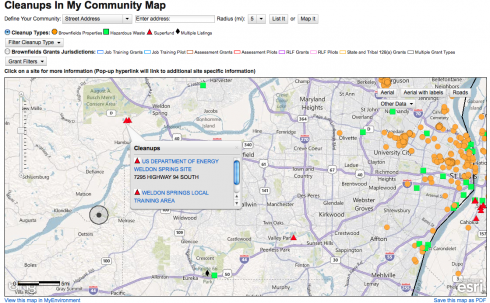
EPA's Cleanups in My Community map for St. Louis and its western suburbs.

Want to find your nearest superfund site? The EPA has an interactive page called, Clean Up My Community, that maps brownfields, hazardous waste, and superfund sites anywhere in the U.S.

Note:

  • Brownfields are places, usually in cities, that can’t be easily re-developed because there’s some existing pollution on the site.
  • Superfund sites are places where there is hazardous pollution that the government is cleaning up because the companies that caused the pollution have gone out of business, or because the government caused the pollution in the first place. The military is probably the biggest source of government pollution, particularly from fuel leaks and radioactive waste.

What does, “Good for the Environment” mean?

Recycling rates for drink containers in the United States.

A number of my middle-school students seemed to believe that recycling is the be-all and end-all of environmentalism.

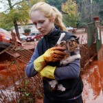
In October, 2010, toxic red mud broke through a holding dam and flooded several towns and flowed into the Mercal River. Red mud is a waste product produced when extremely corosive sodium hydroxide is used to dissolve aluminum out of bauxite. In this picture, "A Hungarian soldier wearing chemical protection gear walks through a street flooded by toxic sludge in the town of Devecser, Hungary on Tuesday, Oct. 5, 2010. (AP Photo/Bela Szandelszky)" (image via The Boston Globe)

We were trying to determine what type of material would make for the best drink bottles.

I have a deep reluctance to reflexively consider anything, “good for the environment,” considering that the environmental impact of any particular product is a complex thing to assess. My students, on the other hand, seem to think that recycling is good and all the rest of it can go hang.

I’d want to add up all the environmental costs: the raw materials; the energy input; the sources of the energy input; and the emissions to the air and water, especially all the other external costs of pollutants that people tend not to want to pay for. To my students, these things have been invisible.

Perhaps it’s the success of the environmental movement that’s pushed things to the background. We’re not struggling through smog everyday – although we’ve had some bad days this summer – and even big issues, like the BP oil spill, are a bit remote and seem so far away.

So, I tried showing the Story of Stuff today. It’s definitely a piece with a “point-of-view”, but I was hoping it would be provocative.

At least 4 people and many animals were killed. Many of the 120 injuries from the red mud spill were from chemical burns. "Tunde Erdelyi rescues a cat from the toxic sludge in the village of Devecser, Hngary on October 5, 2010. (REUTERS/Bernadett Szabo)" from The Boston Globe.

And it was.

It certainly got a lot of the students agitated, ready to challenge its assertions about just how bad pollution problems really are today, which created a nice opening for me to point out the need for skepticism in the face of any information received. Of course, at that point they were probably a little skeptical about me too, but reasoned skepticism is at the heart of the scientific perspective I’d like them to learn as “apprentice” scientists.

I’d like them to read Orwell too, but that’s another battle.

One student was stimulated enough that, I hope, they’ll actually do a little research into the facts presented in the video and present their findings to the class.

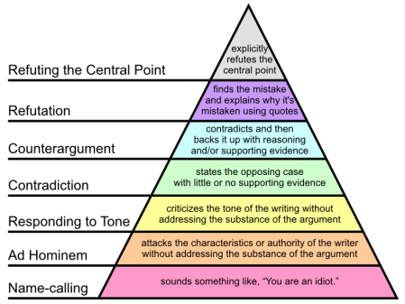
I’ll also have to do a little follow-up on how to argue. In particular I’ll need to post a picture of Paul Graham’s Hierarchy of Disagreement and point out that it’s better to try to refute the actual argument rather than attack the messenger.

We’ll see how it goes tomorrow.

Paul Graham's Hierachy of Disagreement (image adapted from Wikipedia).

Surf Your Watershed: Environmental Data About U.S. Watersheds, and Information on How to Get Involved

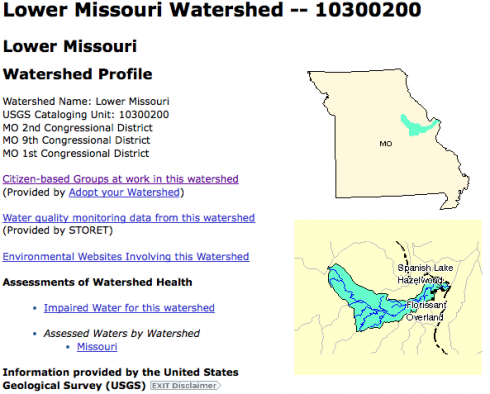
The EPA's Surf Your Watershed site's Lower Missouri page.

The EPA has a number of excellent tools on its website that give access to a lot of environmental information. The Surf Your Watershed pages are particularly nice because they have specific links to citizen-based groups working in your watershed. Ours is the Lower Missouri Watershed, and the groups working there include schools, groups concerned about fish, and land trusts.

The site also links to the USGS streamflow data and some of their scientific research done in the area.

The Story of Stuff and the Life Cycle of a Cell Phone

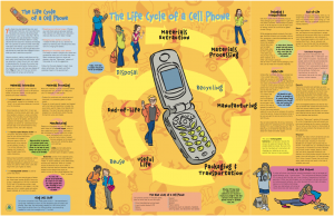
The life cycle of a cell phone. (Produced by the EPA. Link goes to a pdf).

The EPA’s student resource page has a few interesting publications on the life cycles of a few common products: CD/DVD’s, cell phones, and soccer balls.

They’re a bit noisy, and would probably benefit from being reproduced in a more interactive format (Flash maybe), but they’re still a useful resource for talking about life cycles.

They’re a less dramatic presentation which can supplement the advocacy of the Story of Stuff video.

EPA’s Enviromapper

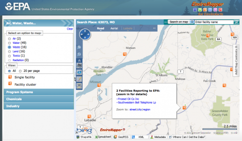
Enviromapper via the EPA. Image links to the map for St. Albans, MO, but you can find information for anywhere in the U.S..

The EPA’s Enviromapper website is great way to identify sources of hazardous materials and other types of pollution in your area, which might be a good way of stirring up student interest in the topic.

Not only can you map the broad category of pollution – air, water, radiation etc – but you can also find specific information about the different types of pollution or potential pollution the EPA has information about. I found a nearby site with sulfuric acid, for example.

And, if you want to slog through a lot of closely written reports, you can find a lot more details about any site you come across. Some of this information might also be useful – who knows?

Breaching the Morganza Spillway

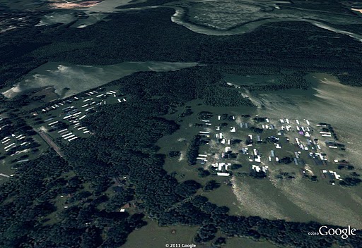
Flooded mobile home park in Memphis on May 10, 2011. © 2011 Google, GeoEye

The worst of this spring’s flood has passed Memphis, but they’re still dealing with the water downstream on the Mississippi.

PBS has before and after pictures of the opening of the Morganza Spillway, which is intended to stave off flooding in Baton Rouge and New Orleans.

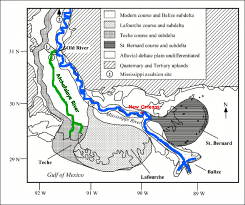
The Coastlines Project blog is also aggregating a lot of information about the effect of the flooding. I found the post on the effect of the flooding on New Orleans) to be particularly provocative. It’s probably a good candidate for a Socratic dialogue, because it points out the tradeoff between the ecology of the Mississippi delta and the health and utility of New Orleans. The Corps of Engineers have been regulating the Mississippi along its present course for the last half a century, but this has prevented the river from avulsing and flowing down the Atchafalaya river instead of its current course. This would leave New Orleans high and dry (but not for long) but be a great boon for the Atchafalaya part of the delta.

The current Mississippi River is in blue, while the Atchufalaya River is in green. The Atchufalaya takes a much more direct route to the Gulf of Mexico, and that is the route the Mississippi would take if it were not for the levees. This map also shows the different deltas built up by the Mississippi River as it has changed its course over the last 10,000 years (the Holocene). Image adapted from Aslan et al. (2005; pdf).

Coastlines Project also deals with other issues, such as how the lingering effects of the BP oil spill, affecting the Gulf coast. It’s an interesting blog to follow, especially since we’ll be on that coast next week for our end-of-year trip.